Comillas offers you 10 walking and cycling tours that will help you discover it in a completely different way.
Comillas
Excelencia Turística
Comillas offers you 10 walking and cycling tours that will help you discover it in a completely different way.

Starting Point: Comillas (20 metres), starting in the Town Hall, situated in the city centre, take the street, Paseo Antonio Garelli, towards the beach.
Length and estimated walk time: 5 kilometres.; an hour and a half without stopping.
Ups and Downs: little more than 100 metres.
Difficulty: slight, even though in the winter there may be mud due to wet weather.
Map reference: the National Geographic Institute, scale 1:25,000 page 33-IV.
Cycling possibility: you can do this route by bicycle except for the stretch between the harbour and the cape Punta de la Moria.
Town Hall (20 metres): Follow the street Antonio Garelli towards the beach, which is busy and noisy during the summer.
The beach of Comillas (5 metres) (0.7km): carry on along the coast; you will pass in front of the fishermen’s facilities in order to get to the harbour.
Harbour (3 metres) (1.1 km): It consists of a small cove that houses the few vessels, which still keep their fishing tradition. Continue straight ahead uphill through the rock-carved stairs that end in the breakwater that overlooks the sea. Head to your left, cross over the esplanade to take the small path, then take the right hand fork, continue and you will come to the end of the track, where is a green-coloured cape that goes down to the blue sea.
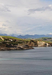
Punta la Moira (20 metres)(1.6 km)(30′): here you will enjoy the wonderful views of the sea. If you look west you will see the cape Oyambre and the Picos de Europa. On the East is the cape Miradorio, outstanding for its faults and the steep-cliff coast. Once you have admired all this beauty you are ready to return, follow the path until you get to the crossroad where you turned before, and go up the road towards the statue of an angel that rests on the ruins.
Cemetery (25 metres) (1.9 km): those Gothic ruins were once the church, but became the cemetery, which is protected by the Guardian angel, sculpted by Jose Llimona. At your left hand side there is a roundabout, you have to go straight ahead and take the right hand fork, which is the coastal access to Trasvía. You should follow the road and turn left when the path becomes a track. It leads to the University. If you follow it you will go under an arch, cross it and you will be facing an abandoned building.

Seaweed warehouse (70 metres) (3 km): The dimensions of this building give us an idea of how important the seaweed collection used to be for food and the production of medicines. Turn right on the first crossroad and left on the second, you will come across oak trees and laurels. When you get to the road where you will find a group of houses. There turn left, you will leave behind the abandoned sports facilities to finally reach a huge neo-Gothic construction.
Pontifical University (80 metres) (4 km): This is another distinguished spot in the village. Although it used to be a seminary for the last few years, it was closed for a time but now is to become an ambitious college of the Spanish Language. If you descend the hill you get to the main entrance arch, where you should turn left to take the Road Manuel Noriega towards the roundabout Doctor Santiago García Castellón. Turn left at the roundabout and you will descend through the road Paeso de Solatorre, where another majestic building is located.
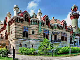
Sobrellano Palace (35 metres): This neo-Gothic building was the house of the first Marquis of Comillas, Antonio López, and next to it are the chapel-mausoleum and the outstanding building designed by the Catalan artist Gaudí, Known as El Capricho de Gaudí, which was refurbished as a restaurant a few years ago. Once outside this majestic building, turn right onto the road Gaudí in order to return to the starting point.
Town Hall (20 metres) (5 km) (1 h 30′).

This route helps you discover the most distinguished spots in the municipality. Most of them are part of Oyambre’s natural reserve.
Starting point: Comillas (20 metres), Starting from the square Plaza Joaquín del Piélago beside the Town Hall.
Arrival Point: Ría de la Rabia (5 metres), the bridge that crosses the lagoon towards the beach.
Length and estimated walk time:2.5 kilometres; 45 minutes.
Ups and downs: slight unevenness, moderate climb to Rubarcena followed by an easy decent to La Rabía.
Difficulty: slight. If you are thinking of cycling, you should reduce speed when passing or seeing pedestrians.
Map reference: the National Geographic Institute, scale 1:25,000 page 33-IV.
Cycling possibility: it is an ideal route for everyone as it runs on a walking path
Town Hall (20 metres): Turn left at the crossroad and follow the sidewalk that runs near the road to Oyambre and San Vicente de la Barquera. This road called Paseo de Solatorre passes nearby the Sobrellano Palace. You will soon get to the roundabout named Dr Santiago Garcia Castellón, where the red-painted cycle path starts. Continue through this slight gradient beneath the majestic buildings of the Pontifical University. At your left there is a housing estate.
Rubárcena (40metres) (km 1): This is the highest point of this cycling path, from then on it gradually descends parallel to the main road amongst the meadows that dominate the landscape. Eventually you get to a new suburb.
La Rabia (15 metres) (km 2.2): It contains a few houses, which are all near the main road. Ignore the right hand fork signposted to Trasvía that takes you back to Comillas and do the same thing with the left hand fork that leads you to Rioturbio and Monte Corona. After a short stretch you get to the bridge that crosses the lagoon where there are usually several types of birds.
Ría de la Rabia(5 metres)(km 2.5)(45′): It is accepted as one of the most beautiful marshlands in Oyambre’s natural reserve as well as one of the entrances to the park from the village. This beautiful spot consists of an estuary interrupted by the dunes that line the beach of Oyambre.

A moderate route that will help you explore the marshland in La Rabia and the municipal district of Rioturbio, one of the main entrances of the Monte Corona forest.
Starting point: Comillas (20 metres), from the square Plaza de Joaquín del Piélago that is beside the Town Hall.
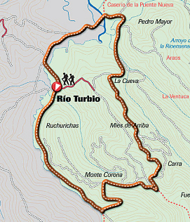
Arrival Point: Rioturbio (10 metres), a splendid and outstanding hamlet situated between the la Rabia lagoon and the Monte Corona forest.
Length and estimated walk time:4.5 kilometres: an hour and ten minutes.
Ups and Downs: around 40 metres uphill and 50 downhill.
Difficulty: slight, be wary of the few cars you may find on the road that leads to Rioturbio.
Map reference: the National Geographic Institute, scale 1:25,000 page 33-IV.
Cycling possibility: You may use your mountain bike but be careful with cars on the stretch to Rioturbio.
Town Hall (20 metres): From the village centre, head towards the La Rabia lagoon through the drive Paseo de Solatorre. You will leave behind the majestic constructions of the Sobrellano Palace and the Pontifical University. Pass the roundabout Dr Santiago García Castellón. The sidewalk emerges onto a cycling path and eventually you will get to a new suburb characterized by recently built houses.
Rubárcena (40 metres)(km 1): when you get to the shelter, turn immediately left, follow the road that leads to an unsurfaced path, away from the houses. Ignore the path to the left and carry on westwards. As the path descends it joins a tarmac road that ends in Rioturbio. If you look to your right you will see a small and beautiful shrine. Continue straight on through the curving lane and eventually you will reach the bridge that crosses the marshland, known as Puente Republicano.
The la Rabia lagoon (5 metres)(km 3)(45′): This narrow road runs between the extensive vegetation of the marshland. For some time the predominant species has been the Baccharis halimifolia, a bush from South America, which has colonised a great part of the area, displacing native flora and thereby altering the ecosystem. It is an almost flat area, so follow straight ahead, cross a bridge and you will arrive at Rioturbio.
Rioturbio (10 metres)(km 4.5)(1h. 10′): This little hamlet is part of Oyambre’s natural reserve and displays a fine collection of tradititional houses. It is a small neighbourhood that leads to the outstanding woods in the Monte Corona forest.

This route takes you inland from the coast to Ruiseñada through the different suburbs in this municipal district.
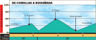
Starting point: Comillas (20 metres), the town hall, situated in the centre of the town.
Arrival point: Ruiseñada (40 metres), given the scattered character of the district, the church of San Adrián has been selected as the arrival point.
Length and estimated walk time:2.5 kilometres; 45 minutes.
Ups and Downs: 100 metres uphill and 80 metres downhill.
Difficulty: slight, except for the mud you may find on your climb to El Pisgu
Map reference: the National Geographic Institute, scale 1:25,000 page 33-IV.
Cycling possibility: You can use your mountain bike even though you may find it difficult when mud covers the climb to El Pisgu.

This route guides you to the most significant hermitage in the Monte Corona forest, and through this extensive, but less well-known mountain area, called Valle del Rio Mato.
Starting Point: the church of Ruiseñada (40 metres), located at the lower part of the centre of this hamlet.
Length and estimated walk time: around 10 kilometres; approximately 2 hours and 45 minutes.
Ups and Downs: little more than 100 metres.
Difficulty: low, the route follows tracks and wide byways. The sole difficulty appears when mud covers the gradient from Rio del Mato to La Molina.
Map reference: the National Geographic Institute, scale 1:25,000.
Cycling possibility: the route can be done on a mountain bike.
Ruiseñada (40 m): Starting from the church of San Adrián, climb eastward along the road, passing but ignoring an exit road on the left. Fork right on the next turning and walk along the meadows, ignoring the paths on each side. This gradient will take you to a wonderful suburb situated on the top of a hill.
La Citrera (90 m) (km 0.7): Once you have left behind the abandoned building of the ancient school, get out of the town through the path to your right. You will go uphill along a tarmac road between oak trees and chestnuts. When the gradient becomes gentler the road emerges onto an unsurfaced path and along the meadows you will get to a junction beside an eucalyptus plantation. Turn left and go up the slope. Eventually, if you ignore the path on both sides you will take a wider path to you left between trees. You will walk straight forward along a plain that connects to a tarmac road, head right and upwards until you come across the slope where this hermitage lies.
Hermitage of San Esteban (251 m) (km 3.2) (50′): this is an ancient viewing point from which you will get a broad view of the coast as well as the mountain area, all of which are indicated. Even though some trees hamper our sight, the view is still spectacular. Nearby there are several picnic areas surrounded by the great variety of trees of this forest such as oaks, beeches, chestnuts, pine and fir trees, larches, cypresses, etc. Go back to the junction and go straight ahead on the tarmac road that rises up to a cabin and another watchtower.
The Fire watchtower and the cabin (280 metres)(km 4.6): both constructions are owned by the forest brigade of Cantabria. Leave those buildings behind and descend straight down through the narrow track that leads to the town of La Hayuela, another of the main entrances to Monte Corona. After approximately 100 metres turn left to take the walk way that descends along a field to go deeper into the wood of oaks, chestnuts, hazels, holly trees. The valley you are descending is situated before the hamlet of Canales, which is also part of the Monte Corona forest. There you will be able to see different species of indigenous and replanted trees. After a long descent you will get to the low part of this valley, then cross a bridge over a small stream.
Río del Mato (60 metres) (km 7.5): this waters flow through a “dead” valley. This is due to the limestone country the underground water flows through to finally emerge near Ruiseñada. Immediately you will come across a second bridge. The plain becomes a gradient and you will progressively get out of the forest to a meadow area. You will climb a more moderate slope this time and emerge onto a tarmac byway. Turn left and you will get soon to a small suburb.
La Molina (110 m) (km 8.4) (2h. 15′): This neighbourhood is notable for its traditional architectural collection but instead of crossing this urban area, pass this hamlet and turn right just beside a small shrine, then descend and cross over a river bed. Go uphill and you will immediately get to the other suburb that is located half way up the hill.
La Citrera (90 metres) (km 9.2): walk between the houses, and once you have passed the building of the ancient school, leave the village through the same street you took when you started this route. Descend through the meadows, ignoring the path on the right. Then turn left on the fork when you reach the fork, you will arrive at the church that was your starting point.
Ruiseñada (40 metres) (km 9.9) (2 h. 40′).

From the shores of the La Rabia basin this incredibly rich forest extends for many hectares. In it is a great variety of replanted trees as well as the precious indigenous oak trees and beeches which are unusual for flourishing so close to the sea.
Starting Point: Rioturbio (10 metres), a beautiful hamlet situated in one of the entrances of Monte Corona. It contains several examples of traditional architecture.
Length and estimated walk time:8.3 kilometres; a little more than two hours
Ups and Downs: around 160 metres of gradients and descents.
Difficulty: slight, except for gradients.
Map reference: the National Geographic Institute, scale 1:25,000 page 33-IV.
Cycling possibility: use a mountain bike be wary with cars when you descending to the hamlet.
Rioturbio (10 metres): Cross through the built up area to the end of the tarmac road where the byway, which goes up the meadows and the forest, begins. The path runs by the stream Rio Turbio, and the wood gradually dominates the landscape. Eventually you will reach a junction, next to a bridge over the river.
Bridge Bichurichas (40 metres) (km 2.2) (30′): It is situated near oak trees, and it is considered the most significant point in the Monte Corona forest. As well as oak trees you will be able to see beeches, holly trees, hazels, birches, chestnuts, etc. Before the bridge turn left to go round the eucalyptus. Going through a gorge you will get to a wider area where there is a junction.
The gorge (156 metres) (km 3.6): ignore the track that goes to San Esteban on your right, and turn left to descend between eucalyptuses until it comes to an open meadow. Ignore the secondary path and you will get to a plain that is connected to a narrow road near the Puente Republicano Bridge and the marshland.
The La Rabia Lagoon (5 metres)(km 6.8)(1h. 45′): if you keep on the left between the extensive vegetation of the marshland, and especially between the Baccaris Halimifolia, the predominant and colonizing bush, you finally return to the starting point.
Rioturbio (10 metres) (km 8,3)(2h. 10′).

This is probably the most complete route of the Monte Corona forest. It will help you enjoy the spellbinding sights and discover the hermitages of San Antonio and San Esteban.
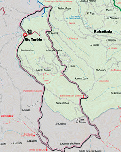
Starting point: Rioturbio (10 m), it is an interesting hamlet located within Oyambre’s natural reserve between the la Rabia lagoon and the Monte Corna forest.
Length and estimated walk time:2.5 kilometres; 45 minutes.
Ups and Downs: around 300 metres in gradients.
Difficulty: slight, except for the small climbs.
Map reference: the National Geographic Institute , scale: 25.000.
Cycling possibility: This route is perfect for cycling but be careful with the cars you may find on the road.
Rioturbio (10 metres): from the urban area the main road emerges onto a byway that rises gradually near the river Rio Turbio, between pastureland, the indigenous and replanted trees. If you keep on walking you will get to a junction where you will turn right, afterwards cross the bridge.
Bridge Bichurichas (40 metres) (km 2.4): this construction is situated near the oak trees of Monte Corona. Once you have crossed it, you will go deeper into the forest. The gradient is moderate enabling you to thus you will be able to enjoy the beauty of this outstanding forest, which is notable for its proximity to the coast and its oak trees, beeches, chestnuts, hazels, holly trees and birches. After a while, you come across a picnic area and a junction.
Junction (200 metres) (km 4.4): fork right, decend until you get to another junction. Then take the tarmac road to the left towards the town of Caviedes. On your way there is a beautiful hermitage made of sandstone and surrounded by a leisure area.
Hermitage of San Antonio (185 metres) (km 5) (1h. 30′): It lies between the trees in a slope that faces West. It is worthwhile to stop there just to enjoy its beauty. Go back to the junction in the kilometre 4.4, turn right and climb up the track that heads East . You will come to a crossroad, turn left between the pine trees and several scattered replanted breeches. Descend the gorge and then climb until you see the leisure area where there are some stone sculptures.
Viewpoint Los pintores montañeses (245 m.) (km. 7,1) (2h. 10′): This spot called Las Argayadas, was built in honour of the painters of the region. As it is located on a slope it has beautiful views of the gall oaks. Go uphill and fork left on the following junction, near the fire watchtower.
Fire watchtower (280 metres) (km 7.8): It is located in one of the top most hills of the forest. From there you can sight a more extensive area. Ignore the path that takes you to the watchtower. Instead, turn left and follow the tarmac road that descends between American oak trees. Eventually you get to a car park, follow straight upwards near the replanted larches, cypresses, pines and chestnuts and continue straight ahead until the next junction. Soon you will see another hermitage on a slope.
Hermitage of San Esteban (251 metres) (km 9.2) (2h. 50′): From this viewpoint is possible to sight almost all the western coast, although some of the trees on the south partially block the sight. In an ancient viewpoint are indicated the most significant places. Return to the crossroad and turn left through a track that descends first between chesnuts and later on amongst pines and eucalyptus. You will soon see a path to your right that leads to Ruiseñada, descend to your left, ignoring all the secondary byways and you will come to a gap (156m) in an area surrounded by eucaliptus,turn right. After a while you get to a flatter surface that is conected to the road near the bridge on the marshland.
The la Rabia lagoon (5 metres) (km 13.9) (3h. 50′): after a few metres you leave the forest and reach the marshland, continue going left and soon you will get to the starting point.
Rioturbio (10 metres) (km 15.4) (4 h. 15′).

This route helps you discover the most distinguished spots in the municipality. Most of them are part of Oyambre’s natural reserve.
Starting point: Comillas (20 metres), from the square Plaza de Joaquín del Piélago, beside the municipal building.
Length and estimated walk time:32.34 kilometres; a little more than 3 hours.
Ups and Downs: little more than 100 metres.
Difficulty: low, it consists of gentle gradients and good tracks except for several stretches, which may be covered with mud. Gradients are steeper for the part that connects Rio del Mato with La Molina (km 18.60 a 8.80), as well as for the part that descends from El Pisgu to El Riguero (km 30,70 a 31,10). Apart from that, there are tarmac byways in urban areas and roads with little traffic.
Map reference: the National Geographic Institute, scale 1:25.000, page 33-lV (Comillas) and 57-II (Cabezón de la Sal).
Cycling possibility: as it has been said, it is possible to do this route on a mountain bike. There are 11.10 kilometres of tarmac roads. A total of 34.3 kilometers divided into 5 stretches, and 2.76 kilometres of wide tracks divided likewise into 3 stretches, which make up 8.5 per cent in all.
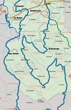
Comillas’s municipal building (km 0) (20 metres): from the town centre take the road towards the beach. On your way you will find a sharp gradient to your left that takes you to an interesting Gothic construction.
Comillas’s cemetery (km 0.62) (25 metres): this consists of a walled construction that once was the town’s church. High up on one wall you will see the unmistakable statue of the Guardian angel, sculpted by Llimona. Turn right towards a roundabout. When you get there follow the roundabout until you come to the exit along the coast, then go uphill to Trasvía. Keep on the main road, passing the University and you will get to a building that once was the seaweed warehouse. Continue straight on and eventually you come up on a tarmac road near the hamlet of Trasvía, from where you will be able to see Oyambre.
Trasvía (Km 2.84) (60 metres) (15′): keep going left and you will reach a junction where there is a hotel. Pass the hotel and go downhill to your left. You will see the football ground beneath you. Cross the main road and you will be in a new district of recently built houses.
Rubárcena (Km 4.08) (35 metres): near the bus shelter there is a byway uphill that soon leads to an unsurfaced path. Follow it, you will get to a slope that faces west, which is connected to the road to Rioturbio, which passes near a small shrine and gets to the bridge that crosses the marshland.
The la Rabia lagoon (km 5.91) (3 metres): the flat road that crosses the marshland ends in the scattered hamlet of Rioturbio, which displays a fine collection of traditional houses.
Rioturbio (Km 7,21) (10 metres) (35′): You will cross the village centre and suddenly the tarmac road becomes a track. It is a gentle gradient that runs near the right bank of the river Rio Turbio. The track deepens gradually into the forest. After a climb to the left you will cross a small stream.
Bridge Bichurichas (Km 9.71) (40 metres): this is a bridge situated amongst oak trees. Go uphill through a track that becomes steeper when it gets into the woods of oak trees, beeches, chestnuts, holly trees, hazels, birches, etc. After climbing for a while you will come across a leisure area and a junction.
Turning for the hermitage of San Antonio (Km 11.76) (200 metres): at the junction take the right hand fork that descends gradually. Ignore the first exit to Caviedes and you will reach a beautiful spot where is a building made of sandstone.
Hermitage of San Antonio (Km 12,32) (185 metres) (1h. 20′): it is situated in a slope that faces west and it is surrounded by a leisure area. If you return to take the same path, you will keep on climbing to your right until you get to a junction where you should fork left. Cross over a small valley and you will reach a spot where there are tables as well as sculptures.
Viewpoint los Pintores Montañeses (Km 14.39) (245 metres): this viewpoint was constructed in honour of all the painters in Cantabria. This spellbinding spot is the best viewpoint to sight the oak trees in the forest, which are not usually found so close to the sea. The track continues uphill and ends in a big field near a cabin and a big watchtower
Turning for Ruiseñada (Km 15.65) (250 metres): now you are descending towards a spot where the landscape is dominated by oak trees and chestnuts, but which is less extensive than the wood near the stream Rio Turbio. You will come to a replanted area, full of interesting species such as eucalyptus and pines characterised by their rapid growth. You will eventually get to the base of the forest where you will have to cross a bridge.
Río del Mato (Km 18,30) (63 metres): the valley is characterised by its karst features where the waters flow underground. Cross another bridge and continue uphill through a sharp gradient that becomes gentler as it joins the tarmac road to the left, which in turn leads to a new suburb.
La Molina (Km 19,28) (110 metres): ride past this suburb but do not enter it. When you get to a small shrine turn right, cross the riverbed and climb the slope in order to reach the next group of houses.
La Citrera (km 19t96) (90 metres) (2h.): just before the ancient school there are two turnings to your right. Take the first concrete road. There is a gradient that becomes easier as it passes between the meadows, and then you will come to a junction where you should keep to the left near the eucalyptus. Ignore secondary paths and when you come to a bigger junction take the left turning. After a plain stretch there is another crossroad. Turn right at the crossroad and immediately you will reach the hermitage on the slope.
Hermitage of San Esteban (Km 22.59) (251 metres) (2 h. 20′): This emblematic spot of Monte Corona offers you beautiful sights of the western coast. Besides, it is surrounded by several leisure areas. Return to the crossroads, take the path to the left towards La Citrera, but this time fork left on the following junction and descend through the extensive wood of eucalyptus. Ignore several secondary paths until you get to a bigger junction where you should keep right towards a plain near the marshland.
Ría de la Rabia (Km 26.87) (10 metres) (2h. 35′): before you reach the edge of the marshlands take the right track. It is a sharp climb that becomes easier as it passes the meadows. It will take you to a new suburb located on the top of a slope.
Araos (Km 27.71) (85 m): once you have reached the tarmac byway, climb the slope between the houses, which will take you to another suburb part of Ruiseñada.
La Ventuca (Km 28.33) (85 metres): If you ignore all the secondary turnings you will easily get to a group of houses. Keep on the main road until you get to the byway that runs near the base of the valley.
Ruiseñada (Km 29,17) (40 metres) (2h. 50′): When you get to this junction, turn left to leave behind the majestic church of San Adrián. You will descend between houses. Fork right to leave the main road.
Turning for El Pisgu (Km 29.57) (25 metres): immediately cross the river Ensenada. It is a beautiful stretch which meanders between alders. Start to climb through a narrow byway between trees. You will pass by a spring called El Pisgu to get to a house and an interesting hermitage.
El Pisgu (Km 30.46) (60 metres): It is located beside the hermitage dedicated to the Sacred Heart. Leave the tarmac road to take a wide byway between bushes, ignoring the immediate tarmac road to the left. You will come to a gentle descent and then a steep climb, which you may find muddy. Continue uphill to your right towards Ruiseñada. After a sharp bend you come to the main road that leads to Comillas.
El Riguero (Km 31.53) (35 metres): now you just have to follow the main road amongst the houses to reach your starting point.
Town Hall (Km 32.34) (20 metres) (3h. 10′).

Ruta circular que, inicialmente, recorre toda la zona litoral de la villa pudiendo disfrutar con paisajes de extraordinaria belleza y, posteriormente, regresa por la zona interior pudiendo descubrir las poblaciones de Trasvía y Rubárcena.
Punto de partida y llegada: Comillas, partiendo desde el Ayuntamiento nuevo, situado en el centro de la localidad, hay que salir en dirección al mirador de Santa Lucía, pasando por la plaza de la iglesia.
Distancia y horario aproximado: 9 km.; sin contar las paradas se puede tardar alrededor de dos horas y media.
Dificultad: baja, aunque con tiempo lluvioso puede encontrarse algo de barro en algunas partes del recorrido.
Ciclabilidad: La ruta puede hacerse en bici de montaña, aunque, debido a la presencia de escaleras, habría que ir caminando algún tramo entre el mirador de Santa Lucía y la punta de la Moira; además, de en una pequeña cuesta próxima a la punta Cambarro.
Ayuntamiento (20 m.): hay que salir en dirección a la playa, siguiendo la acera del Paseo Antonio Garelli. Sin abandonar el núcleo urbano, se llega a orillas del arenal comillano, bullicioso en los meses estivales.
Ayuntamiento: hay que salir en dirección al mirador de Santa Lucía, atravesando la plaza de la iglesia y callejeando hasta pasar junto a la “Puerta de los Pájaros” diseñada por Gaudí, justo antes de alcanzar la ermita que da nombre al mirador.
Mirador de Santa Lucía (km. 0,5): desde este enclave tenemos unas hermosas vistas de la playa y el puerto. Continuamos camino descendiendo por una rampa y unas pequeñas escaleras que nos llevan hasta la playa; desde aquí, seguimos junto a la orilla del mar y atravesando el aparcamiento nos dirigimos hacia el puerto. En nuestro camino, encontramos elementos propios de la zona portuaria, como “el secadero” (zona donde se secaban las redes), o “las bodegas” (almacenes donde, a día de hoy, siguen guardando los aperos de pesca los marineros).
Puerto (km. 1,5): dentro de esta pequeña ensenada artificial podemos observar alguna de las pocas embarcaciones que se dedican actualmente a la pesca profesional. Tras pasar junto a la lonja de pescado, ascendemos por unas escaleras para llegar a la parte alta del espigón, inmediatamente giramos a la izquierda y nos encaminamos por una explanada empedrada primero y un camino de tierra con varios escalones después, para llegar al cabo más saliente del municipio.
Punta de la Moira (km. 2,1): desde este punto tenemos unas vistas espectaculares de toda la costa; incluso, en días despejados, se pueden ver los Picos de Europa. Además, si miramos mar adentro, quizás podamos descubrir alguno de los cetáceos que surcan las aguas del Cantábrico. Para continuar nuestro recorrido tenemos que volver unos metros sobre nuestros pasos, para continuar de frente por el camino de tierra que nos conduce hasta la parte de atrás del cementerio viejo, desde donde sale una angosta carretera en dirección a Trasvía. Tomamos dicha carretera para ir recorriendo la costa entre pequeñas praderías y pinares de repoblación, donde podemos sorprender pequeñas aves alimentándose de las semillas y los insectos que abundan en estos ambientes.
El Cabrero (km. 3,5): tras llevar un kilómetro de carretera y justo antes de acometer una fuerte subida, llegamos a esta pequeña ensenada rocosa donde abundan unas estructuras colocadas al borde de todo el acantilado. Estos postes, coronados por una polea y unido a un sistema de cables y una cesta, se utilizan en los meses de otoño e invierno para subir la caloca (algas rojas) a tierra; para posteriormente ser transformadas por la industria alimentaria y farmacéutica. Siguiendo el recorrido, ascendemos por la carretera. A unos 200 metros, cuando la subida empieza a suavizar, debemos tomar la pista pedregosa que baja hacia la derecha y continuamos por ella recorriendo el borde de la costa; al llegar a otra zona de postes el camino se estrecha y asciende hasta un pequeño mirador junto a otro “poste” utilizado para sacar algas. Desde aquí vuelve a ensancharse el camino y lo seguimos hasta que se termina en otra pista (a escasos metros de las primeras casas del pueblo de Trasvía); en este punto giramos a la derecha para, continuando siempre por esta pista hasta que se acaba, llegar a la desembocadura de la ría de la Rabia.
El Remanse (km. 5,5): este es el nombre con el que se conoce la pequeña playa de piedras que se encuentra en la desembocadura de la ría y a la que se puede acceder bajando por las escaleras de hormigón. Si se prefiere continuar por la senda hasta el extremo oeste, se llega a otra bajada a la costa donde se observan los restos de unas antiguas piscinas que, tiempo atrás, eran utilizadas como vivero de langostas. Desde este punto, para continuar con el recorrido, tenemos que retroceder sobre nuestros pasos unos 700 metros hasta volvernos a encontrar con las primeras casas de Trasvía; aquí, continuamos de frente hasta llegar a la carretera principal que atraviesa el pueblo, donde hay que girar a la derecha para dirigirse hacia la iglesia.
Iglesia de San Andrés (km. 6,8): construida en el siglo XVIII, destaca su interesante torre de campanas. En la explanada que hay frente a ella encontramos una fuente donde poder refrescarnos. Desde aquí continuamos de frente por la misma carretera otros 100 metros, hasta encontrar un punto de recogida selectiva de basura, en ese punto sale a la izquierda una pequeña carretera que siguiéndola siempre de frente nos conduce hasta la localidad de Rubárcena. En este recorrido pasamos junto a praderías, pequeños cultivos y el “Arboretum de Joyucu”, donde podemos descansar y contemplar las principales especies arbóreas de la región. Finalmente, esta carretera desemboca en la carretera principal “CA-131”; tras cruzarla, nos encontramos el carril-bici que discurre paralelo a dicha carretera y que tomamos hacia la izquierda para, siguiendo siempre de frente, regresar a la villa comillana pasando junto al Palacio de Sobrellano y alcanzando el cruce de semáforos que, girando a la derecha, nos deja en el punto de partida.

Paseo alrededor del núcleo urbano de Comillas, ascendiendo a las colinas que dieron origen al nombre del pueblo.
Punto de partida y llegada: Comillas, partiendo desde el Ayuntamiento nuevo, situado en el centro de la localidad, hay que salir en dirección a Cabezón de la Sal siguiendo el Paseo Gaudí.
Distancia y horario aproximado: 4 km.; sin contar las paradas, se puede tardar alrededor de una hora y media.
Dificultad: ninguna.
Ciclabilidad: La ruta puede hacerse en bici de montaña o de paseo, siempre que cuente con cambios para poder superar las cuestas más empinadas.
Ayuntamiento: hay que salir en dirección a Cabezón de la Sal por el Paseo Gaudí; enseguida llegamos a la pequeña plaza de Fuente Real, de donde salen dos pequeñas callejas; cualquiera de ellas nos sirve para avanzar y llegar al barrio de Sobrellano.
Barrio de Sobrellano (km. 0,3): antiguo barrio de pescadores, formado por las típicas casas en hilera, que se localizaba en esa zona más alta para poder divisar el mar y saber si podrían salir a pescar. Continuando hacia arriba por la carretera, sin desviarnos en ninguna entrada, llegamos al punto más alto de la primera colina (la colina de Sobrellano), donde se encuentran los depósitos de agua de Comillas; nada más pasarlos, tomamos una pista que baja a la derecha atravesando una pequeña zona arbolada.
Jardín del Palacio de Sobrellano (km. 1,2): la zona arbolada que se va recorriendo, hace unos años formaba parte del jardín del Palacio, como denotan algunos árboles exóticos que se encuentran en su interior; además de algunas estructuras singulares, como una puerta de sillería o una pequeña cueva artificial realizada con rocalla; sin embargo, tras desaparecer las labores de mantenimiento, la vegetación natural de la zona está volviendo a recolonizarlo. Continuando el descenso por la carretera, flanqueada en la parte final por monumentales encinas, se llega a la carretera general que sale de Comillas hacia Oyambre. En ese punto, la cruzamos por el paso de peatones que existe en dicho lugar y tomamos la acera en dirección hacia la Universidad Pontificia por la calle Manuel Noriega.
Universidad Pontificia (km. 2,4): una portalada nos da la bienvenida al recinto del Seminario, que encontramos en lo alto de la colina de La Cardosa (segunda colina del recorrido). Atravesada dicha puerta, ascendemos por la serpenteante carretera hasta llegar a un pequeño mirador, junto al seminario Mayor, desde donde tenemos unas espléndidas vistas de la villa. Actualmente, dicho edificio se puede recorrer parcialmente con una visita guiada; además de funcionar como centro de enseñanza, investigación y difusión de la lengua española y la cultura hispánica. Para seguir con el paseo, volvemos sobre nuestros pasos descendiendo de nuevo hacia la portalada del recinto, aquí giramos a la izquierda para continuar por la calle Manuel Noriega en dirección al cementerio.
Cementerio (km. 3,2): situado en un lugar privilegiado, el recinto está rodeado por un muro con elementos decorativos obra del arquitecto Lluis Doménech i Montaner. En su interior destaca un ángel obra de Josep Llimona situado sobre las ruinas góticas de la antigua iglesia de la villa. Tras pasar junto al cementerio llegamos a una rotonda donde seguimos en dirección a Santillana del Mar y, a 75 metros, cogemos la calle que asciende a la derecha (C/Juan Martínez Noriega) hacia la estatua del Marqués.
Estatua del Marqués de Comillas (km. 3,6): homenaje del pueblo de Comillas a la figura de Antonio López. Situada en lo alto de la loma que conduce hacia la tercera colina (colina de La Coteruca), tiene unas vistas privilegiadas de la playa y el puerto. Dado que dicha colina está rodeada por un recinto privado, el ascenso termina en esta zona de la estatua. Desde aquí, tenemos varias opciones para regresar callejeando hacia el punto de partida. Una de esas opciones es continuar hasta el final de la calle Juán Martínez Noriega y yendo a la izquierda llegar al Corro de San Pedro; desde aquí tirar a la derecha para ir paseando por variopintas plazas; progresivamente vamos encontrando la de Luís López, la de la Constitución, la de la Ría de la Rabía y, finalmente, la del Corro Campíos, donde giramos a la derecha por la Calle Cervantes para retornar hasta el Ayuntamiento.