
This route guides you to the most significant hermitage in the Monte Corona forest, and through this extensive, but less well-known mountain area, called Valle del Rio Mato.
Starting Point: the church of Ruiseñada (40 metres), located at the lower part of the centre of this hamlet.
Length and estimated walk time: around 10 kilometres; approximately 2 hours and 45 minutes.
Ups and Downs: little more than 100 metres.
Difficulty: low, the route follows tracks and wide byways. The sole difficulty appears when mud covers the gradient from Rio del Mato to La Molina.
Map reference: the National Geographic Institute, scale 1:25,000.
Cycling possibility: the route can be done on a mountain bike.
ROUTE
Ruiseñada (40 m): Starting from the church of San Adrián, climb eastward along the road, passing but ignoring an exit road on the left. Fork right on the next turning and walk along the meadows, ignoring the paths on each side. This gradient will take you to a wonderful suburb situated on the top of a hill.
La Citrera (90 m) (km 0.7): Once you have left behind the abandoned building of the ancient school, get out of the town through the path to your right. You will go uphill along a tarmac road between oak trees and chestnuts. When the gradient becomes gentler the road emerges onto an unsurfaced path and along the meadows you will get to a junction beside an eucalyptus plantation. Turn left and go up the slope. Eventually, if you ignore the path on both sides you will take a wider path to you left between trees. You will walk straight forward along a plain that connects to a tarmac road, head right and upwards until you come across the slope where this hermitage lies.
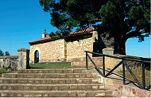
Hermitage of San Esteban (251 m) (km 3.2) (50′): this is an ancient viewing point from which you will get a broad view of the coast as well as the mountain area, all of which are indicated. Even though some trees hamper our sight, the view is still spectacular. Nearby there are several picnic areas surrounded by the great variety of trees of this forest such as oaks, beeches, chestnuts, pine and fir trees, larches, cypresses, etc. Go back to the junction and go straight ahead on the tarmac road that rises up to a cabin and another watchtower.
The Fire watchtower and the cabin (280 metres)(km 4.6): both constructions are owned by the forest brigade of Cantabria. Leave those buildings behind and descend straight down through the narrow track that leads to the town of La Hayuela, another of the main entrances to Monte Corona. After approximately 100 metres turn left to take the walk way that descends along a field to go deeper into the wood of oaks, chestnuts, hazels, holly trees. The valley you are descending is situated before the hamlet of Canales, which is also part of the Monte Corona forest. There you will be able to see different species of indigenous and replanted trees. After a long descent you will get to the low part of this valley, then cross a bridge over a small stream.
Río del Mato (60 metres) (km 7.5): this waters flow through a “dead” valley. This is due to the limestone country the underground water flows through to finally emerge near Ruiseñada. Immediately you will come across a second bridge. The plain becomes a gradient and you will progressively get out of the forest to a meadow area. You will climb a more moderate slope this time and emerge onto a tarmac byway. Turn left and you will get soon to a small suburb.
La Molina (110 m) (km 8.4) (2h. 15′): This neighbourhood is notable for its traditional architectural collection but instead of crossing this urban area, pass this hamlet and turn right just beside a small shrine, then descend and cross over a river bed. Go uphill and you will immediately get to the other suburb that is located half way up the hill.
La Citrera (90 metres) (km 9.2): walk between the houses, and once you have passed the building of the ancient school, leave the village through the same street you took when you started this route. Descend through the meadows, ignoring the path on the right. Then turn left on the fork when you reach the fork, you will arrive at the church that was your starting point.
Ruiseñada (40 metres) (km 9.9) (2 h. 40′).