
This is probably the most complete route of the Monte Corona forest. It will help you enjoy the spellbinding sights and discover the hermitages of San Antonio and San Esteban.
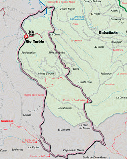
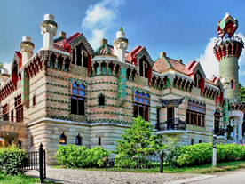
Starting point: Rioturbio (10 m), it is an interesting hamlet located within Oyambre’s natural reserve between the la Rabia lagoon and the Monte Corna forest.
Length and estimated walk time:2.5 kilometres; 45 minutes.
Ups and Downs: around 300 metres in gradients.
Difficulty: slight, except for the small climbs.
Map reference: the National Geographic Institute , scale: 25.000.
Cycling possibility: This route is perfect for cycling but be careful with the cars you may find on the road.
ROUTE
Rioturbio (10 metres): from the urban area the main road emerges onto a byway that rises gradually near the river Rio Turbio, between pastureland, the indigenous and replanted trees. If you keep on walking you will get to a junction where you will turn right, afterwards cross the bridge.
Bridge Bichurichas (40 metres) (km 2.4): this construction is situated near the oak trees of Monte Corona. Once you have crossed it, you will go deeper into the forest. The gradient is moderate enabling you to thus you will be able to enjoy the beauty of this outstanding forest, which is notable for its proximity to the coast and its oak trees, beeches, chestnuts, hazels, holly trees and birches. After a while, you come across a picnic area and a junction.
Junction (200 metres) (km 4.4): fork right, decend until you get to another junction. Then take the tarmac road to the left towards the town of Caviedes. On your way there is a beautiful hermitage made of sandstone and surrounded by a leisure area.
Hermitage of San Antonio (185 metres) (km 5) (1h. 30′): It lies between the trees in a slope that faces West. It is worthwhile to stop there just to enjoy its beauty. Go back to the junction in the kilometre 4.4, turn right and climb up the track that heads East . You will come to a crossroad, turn left between the pine trees and several scattered replanted breeches. Descend the gorge and then climb until you see the leisure area where there are some stone sculptures.
Viewpoint Los pintores montañeses (245 m.) (km. 7,1) (2h. 10′): This spot called Las Argayadas, was built in honour of the painters of the region. As it is located on a slope it has beautiful views of the gall oaks. Go uphill and fork left on the following junction, near the fire watchtower.
Fire watchtower (280 metres) (km 7.8): It is located in one of the top most hills of the forest. From there you can sight a more extensive area. Ignore the path that takes you to the watchtower. Instead, turn left and follow the tarmac road that descends between American oak trees. Eventually you get to a car park, follow straight upwards near the replanted larches, cypresses, pines and chestnuts and continue straight ahead until the next junction. Soon you will see another hermitage on a slope.
Hermitage of San Esteban (251 metres) (km 9.2) (2h. 50′): From this viewpoint is possible to sight almost all the western coast, although some of the trees on the south partially block the sight. In an ancient viewpoint are indicated the most significant places. Return to the crossroad and turn left through a track that descends first between chesnuts and later on amongst pines and eucalyptus. You will soon see a path to your right that leads to Ruiseñada, descend to your left, ignoring all the secondary byways and you will come to a gap (156m) in an area surrounded by eucaliptus,turn right. After a while you get to a flatter surface that is conected to the road near the bridge on the marshland.
The la Rabia lagoon (5 metres) (km 13.9) (3h. 50′): after a few metres you leave the forest and reach the marshland, continue going left and soon you will get to the starting point.
Rioturbio (10 metres) (km 15.4) (4 h. 15′).